 |
Latitudes and the North Star
For centuries mariners navigating the oceans in the northern hemisphere have used the North Star (Polaris) to determine their latitude. For any point between the Equator and the North Pole, latitude is obtained simply by measuring the altitude of Polaris. For example, at latitude N 30°, Polaris can be seen 30° above the horizon. From latitude N 53°, Polaris is 53° above the horizon. If you see Polaris at an angle of 5° above the horizon, you are at latitude N 5°, and so on.
 |
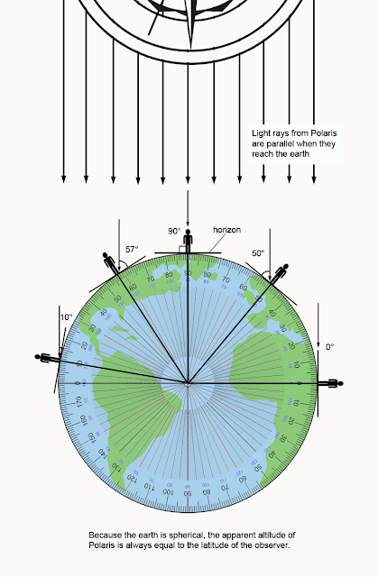
The relationship between latitudinal position and the apparent altitude of Polaris is due not only to the star's distance and location over the north pole, but also to the earth's spherical shape.
Astronomers have determined that Polaris is 433.8 light years from earth. This extreme distance has two important effects:
- It is the reason why the star seems to be stationary, directly above the north pole all year around despite the earth's annual orbit around the sun.
- Light rays from Polaris are virtually parallel when the reach the earth. This means that all light from Polaris meets the earth at the same angle, 90° with respect to the earth's equatorial plane.
Flat-earthers will often protest that it's impossible for Polaris to appear always above the North Pole considering that the earth is traveling around the sun along an orbital path 940 million kilometers in circumference. This argument is actually irrelevant with respect to the shape of the earth and is merely a (bad) argument for a stationary earth. As you will see illustrated below, even if the earth is stationary, its shape can only be spherical.
Nonetheless, flat earthers simply lack understanding of the geometry of the heliocentric model. The distance the earth travels during its annual orbit is minuscule compared to the distance of Polaris.
Consider this:
- The diameter of earth's orbit is about 300 million km (186 million miles).
- The distance to Polaris is around 3.6 quadrillion km (2.4 quadrillion miles).
- That's a distance ratio of 1 : 12,000,000
To put that into perspective, imagine you are staring straight ahead at a distant mountain located 100 kilometers away. Now take a step eight millimeters to the left. Obviously you are still staring straight at the mountain. If you are the earth and the mountain is Polaris, that 8 mm distance is the equivalent of the change in earth's relative position after six months of orbit.
How Looking Up ↑ Reveals Earth's Curvature
 |
| (click to see full size) The angles at which we observe Polaris from any location in the northern hemisphere match perfectly with the geometry of a spherical earth. |
Polaris Can't Help Mariners Find Their Latitude on a Flat Earth
All of the methods and formulas used in celestial navigation employ the geometry of a spherical earth. The fact that they work is no mere coincidence. In fact, if the earth was flat, the methods would not work at all. The geometry of a flat earth is very different and would require different methods.
For example, the congruous relationship between the altitude of Polaris and latitude of the earth is impossible on a flat earth. To a traveler on a flat earth who is moving away from Polaris directly south, the apparent altitude of the star will decline, but not at a constant rate as would be seen on a globe. In fact, the farther away the observer gets, the slower Polaris will appear to descend. It's a matter of simple geometry. As the degree of altitude decreases, concurrent distances increase exponentially. This means that the altitude of Polaris will almost never agree with an observer's latitude. To see Polaris at an altitude of 0° on the horizon (as is observed at the equator) would actually be impossible because an observer would have to be an infinite distance away. Basic trigonometry reveals why. If you can solve a right triangle (or use an on-line right triangle calculator), you can verify this for yourself.
In the below illustration, which is drawn to scale, you can see that Polaris -- if positioned at a height of 3,100 miles above a flat earth (as an example) -- will have the correct matching altitude angle from latitude N 45°, but not from anywhere else except the North Pole.
 |
| Illustration showing altitude angles of Polaris on a flat earth. Distances are to scale. (click to view full size). |
 |
| Where is Polaris on a flat earth? This illustration shows why the altitude of Polaris cannot match an observer's latitude on a flat earth. |
There is no way to reconcile this inconsistency of the flat earth model with observable reality. The apparent position of Polaris in the sky, as observed from any location in the northern hemisphere, indicates beyond question the curved shape of the earth. This is empirical evidence that anyone can validate for themselves by simply measuring the altitude of Polaris with a homemade clinometer and comparing the result to their latitude. If they match, you're on a curve. There is no theoretical distance above a flat earth where Polaris could be positioned that can mimic this relationship. It's impossible. A flat plane can't mimic a curve.
Watch this excellent video for more info:
False Claims About Polaris
Some flat-earthers claim that Polaris can be seen from latitudes well
south of the equator, as far as the Tropic of Capricorn at 23.4° S latitude. This is
absolutely false, of course, which is why they can't substantiate such claims with verifiable evidence, or any credible sources, i.e., sources other than archaic, pseudoscientific, flat earth texts.
In truth, Polaris is typically not visible from locations near the
equator. It's not bright enough. Like most stars near the horizon, its light dissipates due to increased atmospheric interference (a.k.a. atmospheric extinction) and because of light pollution, that artificial skyglow that hangs over
populated areas. However, under the right circumstances, from remote locations, Polaris can be observed south of the equator. This is due to atmospheric refraction which
will cause objects in the sky to appear slightly higher than their actual
positions.
 |
When light passes from one medium to another it is bent, or refracted, and the same is true when light from a star passes from the vacuum of space into the Earth's atmosphere. The result is to make the object appear at a higher altitude than is really the case, and the nearer it is to the horizon, the more pronounced the effect, even causing objects below the horizon to appear visible. The degree by which the light is refracted is also dependent on atmospheric pressure and temperature. All astronomical observations have to be corrected for atmospheric refraction to obtain true, as opposed to apparent, positions.
|
Atmospheric refraction is nil for celestial objects directly overhead and
increases progressively for objects at lower and lower altitudes. The
displacement effect of refraction is well known to astronomers and
navigators. Navigators use mathematical formulas to correct for it. The
refractive index of air is relatively small, so in general the effect is
minor except when objects are close to the horizon.
For example, a star at
an altitude of 45° will appear displaced by only about 1 arc minute or 0.016 degrees. A star significantly lower at an altitude of 15° will appear about 3.6 arc minutes higher than its actual
position, still only 0.06 degrees off. For objects located very near the
horizon, refraction increases significantly and can vary quite a bit depending
on the temperature, pressure, and humidity of the surrounding air. Typically, for
a celestial object right on the horizon (at an altitude of 0°), refraction will
be around 35 arc minutes or about 0.6 degrees. This means that, from low elevations, Polaris could be visible south of the equator, but it's not likely to be seen beyond 1° S latitude.
Viewing from higher elevations such as from the top of a mountain would also increase the visibility of Polaris from southern latitudes, but again, not by much. An elevation of 10,000 feet for example would allow only about 0.5 degrees of increased visibility "around" the Earth.
The above numbers were taken from Astrophysical Quantities by C.W. Allen. For more information on atmospheric refraction and to further verify those figures, refer to the following sources:
Links:
- How to find your latitude from Polaris- How to Find Polaris
- How to Make a Cheap Clinometer
_______________________
The Sun Also Reveals the Shape of The Earth
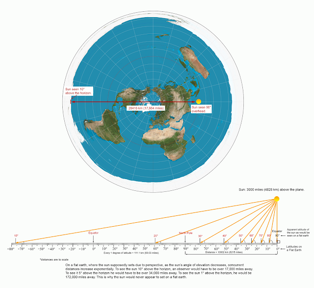
It's not just Polaris that doesn't jibe with the flat earth "model". None of the celestial objects above a flat earth would appear where they do in reality, including the sun.
 |
| (click to see full size) Because the earth is a sphere, on the equinox, at solar noon, an observer's latitude is always equal to the sun's altitude subtracted from 90°. latitude = (90° - altitude) |
Like Polaris, the sun is far enough away that its rays are virtually parallel when they reach the earth. During equinox, the sun is positioned directly over the equator, therefore the sun's angle of altitude will be 90° at the equator and 0° at the poles. With regard to latitudinal position, this means that an observer's latitude will always be equal to the sun's angle as measured from 90 degrees overhead (the angle that is complimentary to the sun's altitude). This is called the Zenith angle.
Finding the sun's zenith angle is how celestial navigators use the sun to determine their position of latitude. During equinox, at solar noon, the sun's zenith angle will always be equal to the latitude from which it is being measured. To find the sun's zenith angle simply subtract its altitude from 90°. For example, if you are in New Orleans which is at a latitude of N 30°, at solar noon, on March 20, you will see the sun at (90° - 30° =) 60° above the horizon. If you are in Edinburgh, Scotland located at N 56° you will see the sun at (90° - 56° =) 34° at solar noon. From Minneapolis, MN you will see the sun at 45° because it lies at N 45° latitude. On a flat earth this would be impossible. As with Polaris, on a flat plane, the sun's altitude is not directly related to latitude, so that simple formula--which mariners have used for centuries to determine latitude while navigating the oceans--cannot work on a flat earth.
This geometric failure of the flat earth model is not a trivial one and is damning for reasons beyond geography and navigation. For example, the sun would never actually set on a flat earth, or even appear close to setting. The earth is way too small. Here's why:
It doesn't have to be the equinox to determine your latitude using the sun. It can be done anytime of year once the sun's declination has been factored in. Watch the video below to learn how to find latitude using the sun. This is also a way to prove to yourself that the earth is round.
Want to prove to yourself that the earth is round? It can be done using nothing more than a stick and a ruler.
Find out how to do it here:
How To Disprove The Flat Earth
Find out how to do it here:
How To Disprove The Flat Earth
* * * * *


